Point Lobos State Natural Reserve
Point Lobos State Natural Reserve is a protected coastal area located along the central coast of California, just a few minutes south of Carmel-by-the-Sea and about 15 minutes from Monterey. It's part of the California State Parks system and is famous for its stunning views, rich wildlife, and unique geological formations. The name “Point Lobos” comes from the Spanish “Punta de los Lobos Marinos,” meaning “Point of the Sea Wolves”—a reference to the sea lions that used to gather on the offshore rocks.
Nestled just south of Carmel-by-the-Sea along California’s rugged coastline, Point Lobos State Natural Reserve is often called “the crown jewel of the California State Park system”—and after visiting, I can see why. With its windswept cliffs, turquoise coves, and whispering cypress forests, this spot feels like a secret portal to the wild beauty of the Pacific.
🌿 Nature and Class Collide: Real-World Ecology
Being out there brought our class topics to life—marine biodiversity, ecosystem balance, and the impacts of climate change. In the tide pools below, sea stars, anemones, and crabs competed for space. The water was crystal clear, making it easy to observe these tiny but vital marine communities.
I also learned Point Lobos sits along the Pacific Flyway, a major migratory route for birds. It’s a stopover haven for wildlife and a living reminder of how connected Earth’s ecosystems are—even across continents.
🐋 Hidden Surprises
Fun fact: Point Lobos was once home to a whaling station. You can still see the remnants near Whalers Cove, where 19th-century Chinese and Japanese fishermen lived and worked. Today, instead of harpoons, visitors bring binoculars to spot gray whales, sea otters, and even the occasional humpback during migration season. I didn’t spot any whales this time—but I did see harbor seals lounging on the rocks like sunbathers on vacation.
🌍 Reflection: A Place to Breathe
Point Lobos is more than a beautiful place—it's a reminder of how fragile and precious nature is. This hike was the perfect opportunity to unplug, reconnect, and reflect on how everything we learn in class actually plays out in the real world. The balance between human impact and natural preservation is delicate—and places like this help remind us why that balance matters.


Top Trails to Try
1. Cypress Grove Trail
-
Length: 0.8 miles (loop)
-
Time: ~30 minutes
-
Highlights: Rare Monterey cypress trees, cliff views, dramatic waves
-
Difficulty: Easy
2. South Shore Trail
-
Length: 1.5 miles (one way)
-
Time: ~1 hour round trip
-
Highlights: Crashing surf, tide pools, panoramic ocean views
-
Difficulty: Moderate (rocky sections)
3. Bird Island Trail
-
Length: 0.8 miles (loop)
-
Time: ~40 minutes
-
Highlights: China Cove, nesting seabirds, turquoise waters
-
Difficulty: Easy
4. Whalers Cove & Whaling Station Museum
-
Explore: Historic buildings, calm waters, diving launch area
-
Great For: History lovers and photography
Where Land Meets the Infinite
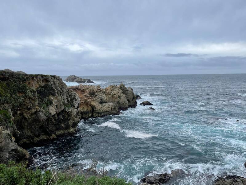
From the moment I stepped onto the trail, it felt like I was walking through a live nature documentary. The paths wind through rare Monterey cypress groves, some of the only ones left in the world. The trees twist and bend with the ocean wind, their bark rugged like the cliffs they stand on.
I followed the South Shore Trail, which hugs the coastline and offers breathtaking views of the waves crashing into black volcanic rock formations. Bird Island Trail took me to a lookout where I saw hundreds of seabirds nesting on a rocky outcrop just offshore—gulls, cormorants, and even a few brown pelicans gliding through the salty wind.
📍 Location
Where:
Located along Highway 1, just south of Carmel-by-the-Sea, about 15 minutes from Monterey, CA.
GPS Address:
62 California 1, Carmel-By-The-Sea, CA 93923
Hours:
8 AM – 5 PM daily (last entry 4:30 PM)
Create Your Own Website With Webador